
Home › Forums › PLACE Forum › Ingleston (Twynholm)
- This topic has 8 replies, 1 voice, and was last updated 5 years, 11 months ago by
John Shields.
-
AuthorPosts
-
July 8, 2020 at 8:36 am #1297
John Shields
KeymasterFrom Alan James – 27 June 2020
Herewith notes on this farm, just outwith Borgue parish but I’m glad Rachel collected these from Robert Maitland, there are some very interesting ones among them, and it close to a fascinating cluster of ancient sites (The Doon, Twynholm Motte and Arden/ Campbelton Motte) and the heart of what was probably the main power-base between the Dee and the Fleet in Northumbrian times. So the presence of up to four possible Brittonic/ Cumbric names is quite exciting: in order of likelihood, 1 Trascallie, 2 Minniebois, 3 Corse Loch, 4 Walltrees.
I’m copying to Mike Duguid, as it’s his stamping ground, and David, Simon and Gilbert may all find points of interest here.
Comments and additional information will be welcome as ever, perhaps even more so!
Alan
July 8, 2020 at 8:37 am #1298KeymasterFrom Michael Ansell – 27 Jun 2020…
Good afternoon Alan, very interesting. One thought would Minniebois not be the same as Monybuie near Corsock with English plural, ie probably monadh + buidhe?
Kind Regards
Michael
July 8, 2020 at 8:40 am #1299KeymasterFrom David Devereux – 29 Jun 2020…
Morning Alan
Thank you very much for notes on the Ingleston names gathered by Rachel.
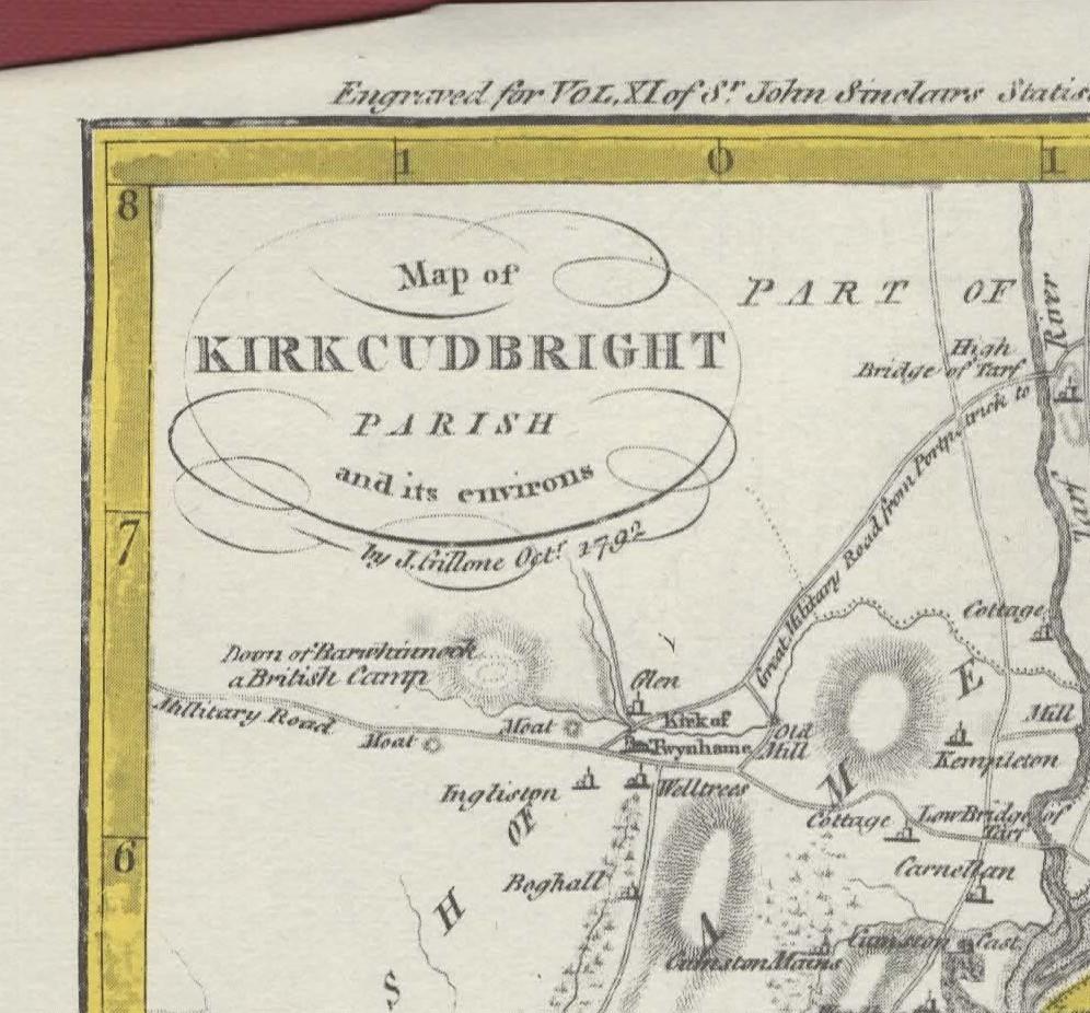
Walltrees caught my immediate attention as I have copies of early/mid 19th century documents relating to the property when the McCourtie / McCourty family were owners. Please find attached a scan of a section of John Gillone’s plan of Kirkcudbright parish (1792) prepared for the 1st Statistical Account. As you can see, fortunately for us he strayed across the border to include Twynholm and Walltrees. The map shows how Walltrees stands at the head of a burn which runs southwards, so a derivation of the p-n to include wælle or wella with the meaning ‘spring’ would seem to be appropriate geographically here. But your suggestion of a Celtic origin for the name is very interesting, and perhaps it may be historically significant that the site lies on the same watershed ridge (with the eastward flowing Kirk Burn to the north) as the church and motte.
best wishes
David
July 8, 2020 at 8:43 am #1300KeymasterFrom Alan James – 27 Jun 2020
Thanks Michael
I agree the possibility of monadh-buidh should be acknowledged, though monadh itself being pretty surely from mönïδ, a pre-existing Brittonic name can’t be ruled out. But, while it’s often difficult or impossible to distinguish ‘Mony’ a mönïδ from monadh, forms with Min-, and especially Minni-, don’t in general seem to me to have definitely Gaelic specifics, I think they’re more likely to reflect the Brittonic variant mïnïδ. But without much more and earlier documentation, the health warning is certainly necessary
July 8, 2020 at 8:43 am #1301KeymasterFrom Michael Ansell – 27 Jun 2020…
Very much agree Alan, the other complication being the apparent ease with which pronunciations fluctuate between ‘Mini’ and ‘Moni’ as in Moniaive – to this day.
Kind Regards
Michael
July 19, 2020 at 5:58 pm #1379KeymasterFrom David Devereux – 29 June 2020
Morning Alan
Thank you very much for notes on the Ingleston names gathered by Rachel.
Walltrees caught my immediate attention as I have copies of early/mid 19th century documents relating to the property when the McCourtie / McCourty family were owners. Please find attached a scan of a section of John Gillone’s plan of Kirkcudbright parish (1792) prepared for the 1st Statistical Account. As you can see, fortunately for us he strayed across the border to include Twynholm and Walltrees. The map shows how Walltrees stands at the head of a burn which runs southwards, so a derivation of the p-n to include wælle or wella with the meaning ‘spring’ would seem to be appropriate geographically here. But your suggestion of a Celtic origin for the name is very interesting, and perhaps it may be historically significant that the site lies on the same watershed ridge (with the eastward flowing Kirk Burn to the north) as the church and motte.
best wishes
David
July 19, 2020 at 5:59 pm #1380KeymasterFrom Alan James – 29 June 2020
Thanks David, that’s very helpful.
I see John Gillone spelt it ‘Welltrees’, there evidently was a spring there and the name was at least interpreted as a refernce to that source. All the same, it’s a slightly odd name, a singular wælle-treow, for a prominent, landmark tree would be more typical, but of course the plural could have been added when more trees had sprung up. I think Ockham’s razor can be applied to my Brittonic suggestion.
Gillone’s map does illustrate well what a prominent location the village centre holds. I think we can be pretty conifdent that it was the power-centre dominating the lands between the lower Dee and the Fleet estuary, becoming (as I argued in my ‘Angles and Britons around Trusty’s Hill’ article) the main centre of Northumbrian control in the 7th – 9th centuries, until challenged by the Norse settlement in Borgue in the 10th. The close cluster of The Doon, a definite motte, and another fort of some kind, is very curious (though a motte next to, rather than re-using, an existing dun is paralleled close by at Boreland of Borgue).
Gilbert has lately discussed ‘Desnes’ in the Facebook Scottish P-Ns group, suggesting ‘Ness of the Dee’, which is at least a possibility. I first thought the Ross would be the best candidate for the eponymous headland from which the district(s) was/were named, but then it occurred to me that, in the 12th century, the L- shaped peninsular ridge eventually followed by Kikcudbright High Street, with Moat Brae at its tip and the castle on the angle, would have enclosed at least a tidal sea-loch (where Harbour Square, St Cuthbert St and the Soaperie Gardens are now), and might have been so-named (the name Kirkcubright, of course, would at that time have primarily referred to the old church site up above) How does that compare with your impression of the medieval geography?
All the best
Alan
July 19, 2020 at 6:00 pm #1381KeymasterFrom David Devereux – 2 July 2020
Morning Alan
I’ve just found Gilbert’s piece on Desnes and will look forward to reading that further. My impression of the medieval geography of Kirkcudbright and St Mary’s Isle (Trail) is broadly the same as yours. Based on recent research in Wigtown Bay near Creetown, our local sea level was at least 1m higher 2000 years ago, so that at a very high tide St Mary’s Isle may well have been an island, and Sandside and the area just north and west of Park House inundated. In the town itself there was a tidal creek which ran probably from behind the museum through the parish church grounds / Soaperie Gardens and then through the present Harbour Square. Overall I have the impression of a long promontory from the site of the present town to the tip of St Mary’s Isle, and the attached English Spy’s map of the 1560s (original in the British Museum) seems to support that, although particular details may be inaccurate and drawn schematically – particularly in the layout of the town and the exaggerated northward extent of Manxman’s Lake.
best wishes
David
July 19, 2020 at 6:01 pm #1382KeymasterFrom Alan James – 2 July 2020
Thanks David, that’s a very nice sketch-map isn’t it? Pretty surely based on observation from a vessel sailing up through the Bay, not getting a clear view of the east side of St Mary’s Isle.
What you say about the relative sea-level is pretty consistent with Peter Friend’s account in his Collins New Naturalist ‘Scotland’ 2012, 59 – 62 and 87 – 91. As his figs. 43 and 56 show, in the past 3500 yrs or so, there’s been a fairly steady drop of at least 0.5mm p/a, which over the centuries would have made enough difference for spring tides to encroach on, and storm surges to flood, over several locations that are now dry land. As well the slow retreat of the sea, the formation of dunes and shingle bars whould have modified the geography – that may apply to the St Mary’s Isle isthmus, maybe even to the lowest part of St Cuthbert St. And I’m sure Senwick was, when the Scandinavians named it, at the head of a sandy creek, sand vík, a good half-mile inland from the present head of Brighouse Bay. It would also explain the location of the Roman fortlets on the Fleet and the Bladnoch, at crossing-points above where the tide normally reached 2000 years ago.
All the best
Alan
-
AuthorPosts
- You must be logged in to reply to this topic.